| Author
|
Thread |
 
|
|
|
|
April
Joined: 13 Dec 2003
Posts: 6593
Location: Westchester/NYC10/16/14 11:14 AM |
Nothing in the Garmin mention barometric altimeter.
Even after I apply the elevation correction, it still doesn't match up with the eexact same route I plotted using RWG! Go figure.
I'm also getting rather disillusioned with the Garmin on the ride too. It may have to do with my choice of rides, always off major road and often have thick tree overhead. The Garmin simply doesn't call out the turns until I've gone past it half of the time! And no, I don't ride THAT fast!!! ;-)
|
|
 |
|
|
|
|
|
rickhardy
Joined: 11 Jan 2004
Posts: 1492
Location: Needham outside of Boston - the hub of the universe10/16/14 12:08 PM |
April there is some fix on late turn indicators
I read something on some boards that Garmins can be tweaked to resolve this. Just google it there are discussion boards just about gps for cycling....
|
|
|
|
|
|
|
|
Tim123
Joined: 01 Apr 2004
Posts: 252
Location: Adelaide10/16/14 4:02 PM |
The problem with using altitude correction on Strava or any other site, or the default Strava data when using a mobile device or something without a built in barometric altimiter is that "Strava" can only estimate your altitude by using known topographic data of locations "near" where you ride. Trouble is this is only as acurate as the map data allows (number of data points) and their location relevant to the actual road or trail that you were on. If the nearest data point is at the top or bottom of a hill, then that is what your current elevation is shown as. All of this extra up and down is what usually exagerates Strava's vertical gain. Around here, it's generally plus 30% of gain.
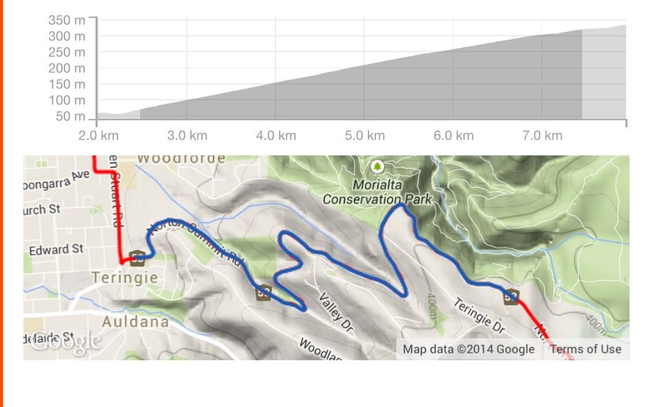
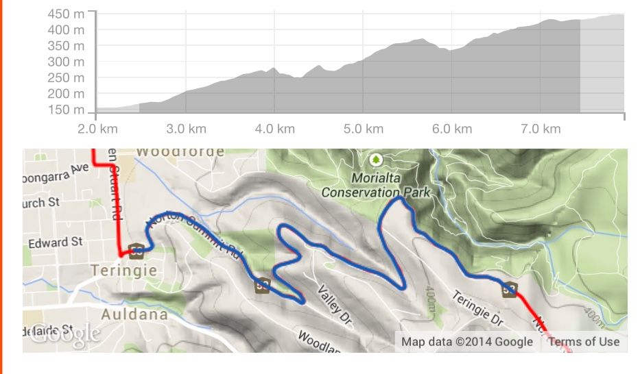
If you look at some of the segment profiles before and after you apply altitude correction, they can be quite different. For example there is one here that is around 5.1km in length and is a fairly constant 5% grade for it's entire length, after altitude correction is applied, it shows there are downhill sections in the middle of it, which there definitley is not!
Here is the segment i was talking about, same ride, just before and after altitude correction was applied, you can see all the additional ups and downs in the second pic. Overall altitude gain for the ride went from 829m to 1204m.
Should probably mention that this ride was done with a Garmin Edge 510
Last edited by Tim123 on 10/17/14 10:42 PM; edited 1 time in total
|
|
|
|
|
|
|
|
April
Joined: 13 Dec 2003
Posts: 6593
Location: Westchester/NYC10/17/14 9:56 PM |
My experience is the opposite. When elevation correction is applied, the total typically goes DOWN.
Today, I got a glimpse of why my Garmin was late in calling my turns. At more than one turn, I could see the street sign so I know it's my turn. But since I was shedding clothing, I thought I check the map just to be sure. Each and every time, it doesn't know where I was! No wonder it didn't call the turn. It didn't think I was at the corner!
I'm typically riding in roads with thick canopy of foliage. View of satellite are often compromised. The GPS isn't smart enough to guesstimate my location either. It's a physical limitation not a technological one.
I think the GPS might be going back to REI (where I bought it from). It's somewhat helpful but not entirely useful, especially not reliable without back up by cue sheet/computer. And at $200+, it's not quite justifiable for such limited functionalities.
|
|
|
|
|
|
|
|
ErikS
Joined: 19 May 2005
Posts: 8337
Location: Slowing boiling over in the steamy south, Global Warming is real10/18/14 5:37 AM |
Strava told me to turn of the Auto Pause feature.
They side stepped the data being bogus.
Their suggestion did not help.
http://app.strava.com/activities/208399765
This is still way OFF.
E
|
|
|
|
|
|
|
|
April
Joined: 13 Dec 2003
Posts: 6593
Location: Westchester/NYC10/18/14 9:48 PM |
Another disappointing day with the Garmin.
Today's route is quite convoluted and has many quick turns one after another. That's the sort of route that some navigation aid would be welcome addition to the tried-and-true cue sheet method. Sadly, the Garmin failed miserably. It didn't seem to have accurate enough position information to tell that I need to make the next turn.
And this time, foliage canopy can't be the excuse. I was in rather wide open area. It's just the accuracy of the position that got the Garmin confused. (and when Garmin got confused, it just goes black screen!)
I'm afraid this is the end of my test. I've only got one more week left to ride before I hang up my bike for the season. I've seen enough of the unit that I'm totally unimpressed with it. Well, not for the price anyway.
|
|
|
|
|
|
|
|
|
 CYCLING TECH TALK FORUM